At 24 miles, 10 canyon/pass traverses and 8,000ft elevation gain, the Stansbury Front Trail (SFT) is an action packed weekend point-to-point hike. Highlights were watching the sun rise over the Great Salt Lake, getting pounded by a thunderstorm in the comfort of my tent, wildflowers everywhere, tons of solitude, a great workout and the massive and beautiful Hickman Canyon.
The Stansbury Mountains sit on the west side of the Tooele Valley and are part of the Wasatch-Cache National Forest. They were wilderness designated in 1984. The most well known and highest peak in the range is Deseret Peak at 11,000ft. The SFT runs from West Canyon in the north to Big Hollow in the south.
*In response to a comment I’ve added some more detail on the trail’s coordinates etc to the bottom of this post. If you’re doing recon on this trail, check out the gps info at the bottom and then read my response to the comment*

My plan had been to drive to the south end of the mountain range, park my car, and get a taxi up to the north end of the range. I had it planned out, or so I thought, with the Tooele Taxi Company, “Yep we can do that, just give us a call when you get to Tooele and we’ll dispatch a driver”. Well, I got to Tooele and gave them a call and the phone rang out and eventually went to a message saying the voicemail was full. When I reached the bounds of cell reception an hour later they still weren’t contactable. I was furious. Uber doesn’t service the area apparently, i’d tried that before coming up with the Toole Taxi Co plan earlier in the day. Out of options, I called a taxi to come out from Salt Lake City. For the nice small fee of $80 and an hour of waiting I could get my ride. The taxi driver told me I was the craziest person he’d ever met a few times during the hour or so long drive. His parting words, as he dropped me at the end of a long dirt road, in the middle of no-where, were simply, “okay then, don’t die out there.” Ha.

Day 1
West Canyon – White Pine Fork Pass
13 miles
I hiked in a couple of miles after the taxi ride last night and camped on a ridge overlooking the Great Salt Lake. Waking at 5:30 a.m. to this incredible sunrise reminded me why I love this backpacking thing so much.


Day 2
White Pine Pass – Big Hollow Trailhead
10 miles
Another beautiful sunrise!


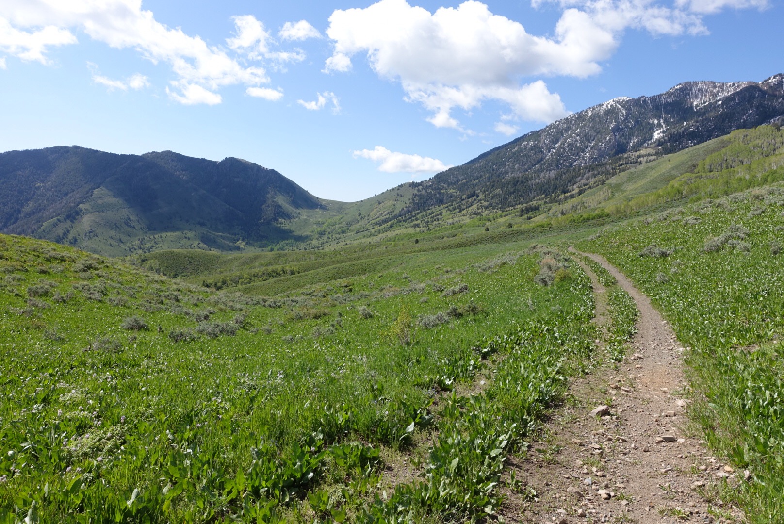
The first 16 miles of the trail traverses rocky passes along the front of the Stansbury Mountains, one after the other in quick succession. I was expecting more of the same to the end of the trail. Hickman Canyon took me completely by surprise. One of my very favorite things about backpacking is the anticipation of what is over the next ridge. It’s times like what i experienced heading into Hickman Canyon that fuels the fire. It was a massive canyon that took more than 5 miles of meandering trail to cross. It…. was…. so…. beautiful! Everything was bright green, wildflowers were sprouting everywhere, the sun was shining, the sky was blue. I felt like it was the set of the Sound of Music and I was Heidi.
After hiking up the other side of the canyon and over Hickman Pass, the last few miles were all downhill as the mountain range dropped away into the desert floor. I arrived at the Big Hollow Trailhead and my car at about 1:30 p.m. Realizing I had plans later that day, I took the opportunity to clean up in a nearby cattle trough.


Thanks for reading.
-Elevated
Here’s some additional info on the trail if you’re planning a trip:
Useful site: http://www.tooelecountytrails.com/stansbury_front_trail.html, although i found the mileage and definitely the gps coordinates to be off.
Here’s the route:

Here’s where I started on West Canyon road, this was about .5 mile from the start of the SFT:

Here’s where I finished at the Big Hollow Trailhead (i was parked about .25 mile from the TH):


A great weekend….lucky you!
Thanks Mum 🙂
What a fantastic walk. I’m glad to hear the body is behaving.
me too! Thank you.
Righto, Heidi. Looks beautiful! Crazy person.
From me
You taught me crazy! xxx
Hey there – found this by way of Google…my friend and I tried to get up there a couple weeks ago by way of South willow canyon (deseret peak trail), but found it still had too much snow a couple of miles in. Your cross-trek sounds like fun though and good to know the snow is mostly melted.
So anyway, I was wondering if you could share some details? Which trailhead or point did your enter at? Was it in North willow?
Was the trail down the range clear/easy to follow?
Thanks in advance!
-Jamie
Hey Jamie!
Glad you found me, i try to put in some detail so i can help out other hikers. 🙂
I’ll bet all the snow drifts have melted by now on the SFT. The trail is 24 miles and starts about .5 miles from where the West Canyon road ends. Navigation is pretty basic, but definitely take a map. The trail finishes in the south at the end of the Big Hollow Road near
Rush Valley. Big Hollow Road is pretty rough to drive, you’ll want a 4WD or to go really slowly.
This site was really helpful: http://www.tooelecountytrails.com/stansbury_front_trail.html, although the mileage was off in a few places and the gps coordinates weren’t accurate. I’m going to edit the post in a minute with some info, gps coordinates etc, that will help supplement the Tooele County site.
Also, the site says that the only reliable water is in 3 canyons. As at the date i hiked, there were a lot of the seasonal sources still running, especially between White Pine Pass and Box Elder Pass, and then also in Hickman Canyon. I wasn’t sure and carried from Medina Flats, but as it turns out it was unnecessary. Better safe than thirsty though!
Have fun! Let me know if you need any more info!
Such a bada$$ Kate!
I thought of you many times actually! I forgot my bug spray and the bugs were out. 🙂
Hey there, I did this over memorial day weekend probably around 1994, stashed my mountain bike in North Willow, drove down to Big Hollow, what a great time! Your description of your adventure brought back great memories. Me and my dog Buddy. Thanks! And yes when I got to North Willow it was packed with people, lucky my bike was discovered by good person.
I loved this trail, such a great hike to have so close to Salt Lake City. One thing I love about the mountains…. they probably didn’t look so different in 1994 when you did it! Thanks for your note.
– Elevated